
750 Miles on the PCT - Again
Words and iPhone photography by Brock Ford

A few hours after dictating this note I sat at the northern terminus of the Pacific Crest Trail, three months of walking north from the Mexico border now behind me. Each member of my trail family followed one by one. Rocket burst into tears, Chimi let out a signature whoop, and Zip, restrained as usual, let out a simple “Oh man,” with a satisfied smile. We spent quality time in that bare dirt patch along the border clearcut, taking our terminus photos, drinking celebratory Rainiers, signing our name in the final trail register of our journey before filtering out one final time, back south for a cruisy repeat of the 30 miles to Harts Pass where life as we knew it on trail would come to an end.
I had no real reaction upon reaching the terminus. My idle time spent sitting in front of the monument post was silent, solemn. It was fucking awesome, of course - I made it after all. I had realized and fulfilled a dream that for years felt unattainable. It was and had been simultaneously an awakening and an affirmation of what I already knew, that fully immersed in nature’s majesty is exactly where I am meant to be. It was the greatest experience of my life. Yet those words from my Notes app, dictated mid-stride on the phone that had replaced the one that got destroyed in Yosemite, dominated my mind. It was the most coherent distillation of what I had been forced to accept over the past few weeks and what echoed in my mind as I watched my friends drink beers from their shoes.
I’d be lying if I said I wasn’t disappointed in how things panned out for us. A series of wildfires had forced us to skip several sections of trail over the past few weeks after 1500 miles of previously uninterrupted hiking. Despite hiking all we could, I didn’t feel like I was finished, and I thought back on the entirety of the past three months in juxtaposition to my imminent return to the real world. The magic of life on trail was, so I thought, incomparable to anything that came after, and there’s no way I wouldn’t want more and wouldn’t return in some capacity regardless of the final outcome.
By March of 2025 I found myself once again burnt out from another winter of seasonal work at Snoqualmie Pass, this time with an additional layer of confounding post-trail depression. I missed everything about the trail - the people, the views, the dirtbag way of life, the simplicity and spontaneity, the unabated freedom (fire closures notwithstanding), and the comfort of knowing I was always exactly where I was meant to be. Aside from a burgeoning Sierra High Route idea with Chimi in August, I had no real plans once ski season was over, and I needed something not just to look forward to, but to reset my mind after the chaos of winter and to at least attempt to repair the PCT-sized hole in my heart.
Pining for inspiration, I revisited my PCT trail journal, specifically my entries from from the San Jacintos and Mission Creek. That stretch was an early stress test for me on my thru-hike: I ran out of food in the San Jacintos on my way to Idyllwild, where I quickly learned of the Norovirus outbreak exploding in the bubble of hikers a few days ahead, suspected at the time to have originated at Mission Creek. My time from Idyllwild to Wrightwood was spent obsessively filtering and disinfecting water and washing my hands every chance I got, resulting in a less than enjoyable week in what is truly one of the most stunning and engaging stretches of the PCT south of the Sierras.
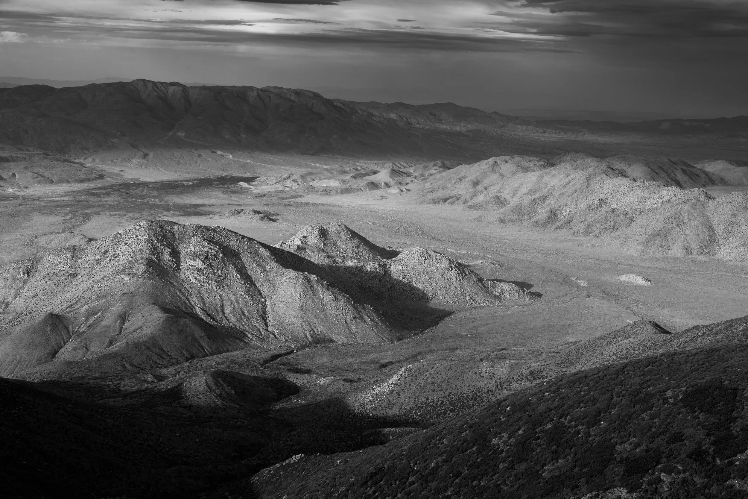
San Jacinto Peak, photographed from Snow Creek on my 2024 thru-hike
An idea had formed - a section hike along the PCT from CA-74 to CA-18; Paradise Valley Cafe to Baldwin Summit, 114.5 trail miles including the blue blaze to the summit of Mount San Jacinto that I had missed on my thru-hike - a revisit, reimagining even, of the section I had mostly suffered and stressed through in 2024 rather than indulging in its inspiring magnitude and beauty, both conventional and unconventional. Sans snow, sans Norovirus, sans uncertainty, I figured this would be the perfect little solo trip to recharge and revitalize my soul. Given my newfound propensity for long, fast days in the mountains, I figured the trip shouldn’t take more than a week with transportation factored in, and it would even be most ideal to go once the Snoqualmie ski season had finished.
It didn’t take long, though, before I found myself scheming up something even bigger and more ridiculous, a wonderfully frustrating trait of mine - I’m always going to want an outing to be bigger and more intense. Soon enough, after some deliberations and difficult conversations, I decided fuck it - I’m just going to redo the whole Desert section. 700 miles of pure, unadulterated, and swelteringly hot fun. That will surely fix my problems and definitely won’t affect anything else in my life in the meantime.
DAy 0
I scanned the crowd at baggage claim in San Diego for anyone even loosely resembling hiker trash, seeking what I thought was a sense of comradery, but the truth is I was seeking validation, reassurance that I was making the right choice. Alas, I was alone, sticking out like a sore thumb in my colorful hiking outfit. I snatched my bright pink Nashy off the carousel and bolted for the exit, lunch and grocery shopping on the docket for the afternoon.
The southern California heat was enveloping, though the worst of the heat was set for tomorrow around the time I started hiking. On my 2024 thru hike I didn’t feel temperatures above 80 degrees until I was already north of Tahoe - I’d experience higher temps just on the 8am walk to the shuttle tomorrow.
I stayed at a hostel just a few miles from the airport in hopes of jumpstarting some good social vibes prior to my hike. That ended up not being the case at all, as I instead spent a long, hot and noisy evening on my top bunk alone. It was a rough night of sleep and an unfortunate vibe to enter Day 1 with, but surely once I was around fellow hikers things I’d feel better…right?
Day 1
There wasn’t much stalling to be done in the morning before making my way to the shuttle stop, where at long last I spotted the fellow hiker trash I had been looking for at the airport. I sat directly on the sidewalk, a subtle attempt to transition my brain to trail life: I am trash now, so I’d better start acting like it. Within minutes there were a dozen of us sharing the bus stop. I could physically feel their nervous excitement, likely a contributor to a noted lack of initial pleasantries between the group. Thankfully there wasn’t long to wait before the shuttle arrived, forcing everyone into quarters so close they’d have no choice but to introduce themselves and unleash that pent up anticipation.
It was through listening to these introductions and backstories, coupled with the shuttle driver’s reciting facts about the trail and pointing out landmarks as we approached Campo that I began to feel somewhat uneasy, out of place. Everything was so familiar to me; I recognized all the landmarks, I remembered where the water sources were, I knew what curveballs to expect from each section of trail, and here I was surrounded by a dozen people having a novel experience with it all, an experience whose magic I remember and that I know will resonate with them forever, chasing a glimpse of that feeling for myself after my experience had run its course. It didn’t feel right. I felt like an outsider despite a familiarity with the trail akin to returning to my home, and it wasn’t sitting right with me.
We were dropped off into 95-degree heat at the terminus, and it wasn’t even noon yet. Those of us who were setting off northbound instead of staying at CLEEF walked to the monument to be greeted by the same two PCT crest runners as last year, Abby and Stoke! I chatted with them about being back only a year later, and they said they recognized me from last year because of my headband. Abby was kind enough to take another terminus photo for me before I set off into the known unknown, chasing the ghost of myself a year prior.
Most of this first day was spent cruising easy trail in downright oppressive heat, such a stark contrast from the cold and wet Cascadian winter. I shared some miles with a first-time thru hiker from Pennsylvania named Tim, and spent over an hour relishing in a precious patch of shade with a half-dozen other hikers in the afternoon. Their excited and uncertain energy provided valuable spiritual nourishment despite my inability to choke down food all day.
I was feeling pretty beat when I reached Hauser Creek 15 miles into the day, my body screaming at me to consume even a single electrolyte. The creek was a meager trickle that stopped flowing within minutes of me grabbing what I needed, much to the chagrin of the dozens of campers nearby. After sucking down just enough food to carry me up the climb out of the canyon, I launched myself up the switchbacks as the sun set.
The temperatures lingered in the low 80s as the fiery sunset burned out, a dire omen for my upcoming sleep quality, but the stoke of hiking past sunset carried me through one last mile under the stars to my campsite under a large manzanita. Cold-soaked dinners would take some getting used to again, but I powered through my Knorr rice concoction before settling in for a restless, sweaty night of something approximating sleep, baffled at where I found myself at this moment - is it weird as fuck that I came back?
Day 2
I start my days on trail at 5am sharp, with the aim to be moving before the sun rises. More crushing heat was on the docket for today, so my main goal was to knock out the long gradual climb towards Mount Laguna before the heat got too bad. Thankfully a thin layer of clouds lingered throughout most of the day, filtering the sunlight just enough to keep the worst of the heat at bay.
The two remaining miles to Lake Morena went by in a flash. I tapped back into my hiker trash brain, finding a vacant RV spot to plug my electronics into before the surrounding campers awoke. After a quick charge I made great time through the easy, familiar terrain past Morena, shocked at how well I remembered every stretch.
Kitchen Creek was my first real stop of the day, where I shared the company of a group of weekend backpackers reveling in the fresh, ice cold water. Having familiarity with the desert water sources this time around made water management much easier, and as such I drastically reduced my carrying capacity for this hike from 6L to 3.5L. I had an understandable tendency to overcarry on my 2024 thru hike but had since graduated to a new tier of weight weenie.
Soon the sprawling, gentle terrain south of Mount Laguna opened up in the distance. I was flying today despite the heat, but the lack of quality sleep the previous two nights was starting to take me down. I reached Long Canyon Creek 20.4 miles into the day, where I had some lunch before approximating a sickening parody of a nap for a couple hours. not a single hiker came by the creek for those two hours, and I pressed onward upon feeling somewhat human again.
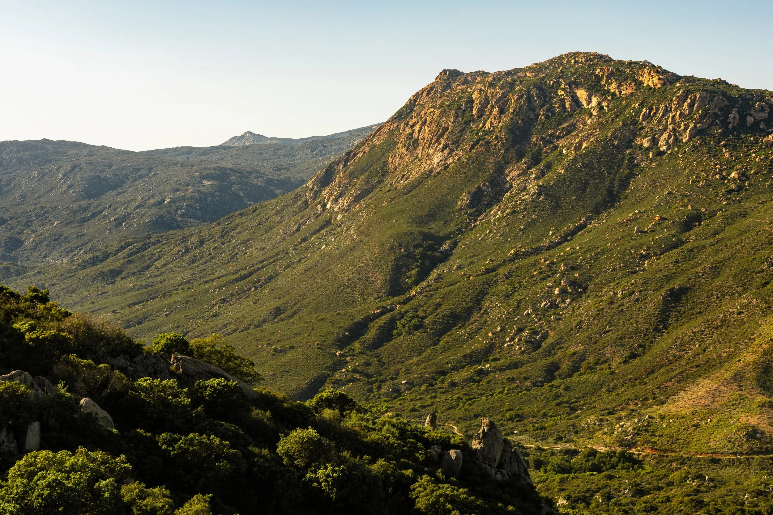
The roughly 30-mile stretch from Mount Laguna to Scissors Crossing is one of my favorite parts of the entire desert section. It’s the first truly grand view a Nobo gets, with the prominent, richly-textured hills of the Anza-Borrego desert stretching all the way to the mighty San Jacinto Peak far in the distance. I took some time to relish in the grandeur as dappled early evening light painted the topographic tapestry thousands of feet below.
The dramatic relief from high elevation ridgelines to the hot desert floor results in clashing temperatures, giving rise to frequent heavy winds through this stretch. I managed to find a mostly sheltered spot in the manzanitas to set up the tent, but the winds were still relentless, making for a third straight night of atrocious sleep. At least the sunset was phenomenal.
Day 3
Day 3’s sunrise was equally stunning, putting on a bright red-orange light show on the faces of Oriflamme Mountain and the entire Anza Borrego desert below. I spent plenty of time snapping photos while being buffeted by wind at a viewpoint just off the trail.
The forecast called for milder temperatures relative to the previous two days, but the winds were raging up high above the desert floor, keeping temps cold enough to warrant wearing my fleece for the first time. The trail weaves its way through every nook and cranny in the hills for miles above Rodriguez Canyon, with nonstop stunning views of the Anza-Borrego desert and prominent Granite Mountain, a beautifully textured mountain whose northern flanks the trail graces prior to dropping to Scissors Crossing. Wild lilacs were in full bloom, contributing beautiful accents of color and a sweet scent to the air in those nooks and crannies protected from the wind’s roar.
The criminally-high dose of cold instant coffee I had been imbibing throughout the morning was no match for the previous three nights of shitty sleep, and though I was making good pace, the fatigue and brain fog was winning the long-term war. I reached Rodriguez Canyon mid-afternoon about 23 miles into my day, where I faced a logistical decision: I planned to hitchhike into Julian from Scissors Crossing tomorrow morning no matter what - the question was how far I wanted to go today. I wasn’t quite on my desired 30+ mile/day pace yet, but going too far and getting too close to Scissors Crossing would mean I’d likely be waiting for a hitch for a while in the early morning cold, whereas forgoing my distance-driven ego and settling for 25-26 miles today would mean I’d be able to kill the early morning hours hiking, likely resulting in a quicker ride tomorrow at a more well-traveled hour - plus I wouldn’t be sleeping beneath a highway underpass.
Thankfully, the decision was made for me a few miles later when I found a perfect, windless campsite next to a massive boulder. I was going to get some real sleep tonight, dammit.
I’m not a fan of spending time at camp when backpacking. I prefer to be moving as long as there’s daylight, but stopping early gave me some valuable time to think on the past few days and sit with the feelings I’d been having. This had already been a much different experience than my 2024 thru-hike, and it’s not like I didn’t know it would be. I was moving faster and more efficiently like I had planned, but this came at a cost I hadn’t emotionally prepared for, which was the lack of social interactions. I hadn’t seen quite as many other hikers as I had expected, and so far I had passed everyone I had seen. My first week on trail in 2024 was spent camping and hiking around at least a dozen familiar faces, whereas this time around I hadn’t seen anyone more than once.
I was feeling more and more like an outsider on a different mission than everyone else, and was treating my status as a section hiker as an indictment against myself. I tried reminding myself why I came back - this was for me, and it’s okay to be by myself for a while. If I was meant to make friends out here this time, I knew it would happen, and I trusted that the trail would provide when the time was right. For now it was time for sleep, and my little boulderside nook afforded me a valuable night of restful sleep I had been missing to this point.
Day 4
I awoke on Day 4 to the sound of gentle drizzle and promptly commended my fatigued self from the night prior for having the foresight to set the tent up. I couldn’t believe how human I felt again after a full night of uninterrupted sleep - had today not been a town day I would have gunned for 35 miles. Alas, I had no food, and a free slice of pie in Julian was calling my name, so I quickly packed up and got moving just as the rain dissipated.
The sun began to slash through the swirling clouds, casting dramatic light on Grapevine Mountain and the surrounding San Felipe Hills. The flat miles to Scissors Crossing are lush with agave, yucca, cholla, and any other desert plant you can imagine, and while past their prime for the season still provided a beautiful foreground to the light show across the valley.
It took less than an hour to reach the highway at Scissors Crossing, where I popped my puffy jacket on and stuck my thumb out for the first time of the trip. I don’t mind hitchhiking as a thru-hiker, and Scissors Crossing to Julian is maybe the easiest hitch of the entire trail thanks to the passionate network of trail angels around Julian who frequent the area to shuttle hikers around. A man who goes by the name Ghost, the same trail angel who picked me up in 2024, pulled into the parking lot within a few minutes of my arrival, and after a quick but entirely unnecessary stop to check on a busted local cattle guard, drove me into Julian.
Resupply in Julian was unceremonious this time around - as a hiker, it’s one of my favorite trail towns in California, but it’s so damn expensive. I went straight for Mom’s Pie for the free slice and some charging before grocery shopping for the stretch to Idyllwild. Last year this stretch took me 5 1/2 days. This time I planned for 4 days and 3 nights. The forecast looked much more hiker-friendly for the next few days, with a chance of a storm rolling through the San Jacintos around the time I got to Idyllwild, meaning a hotel stay may be in the cards for me in Idyllwild.
By the time I hitched a ride back to Scissors Crossing in the afternoon the dramatic clouds had burned off and the sun was shining. The wind kept temperatures nearly perfect while I was moving, but cold the second I stopped moving for any reason. The trail passes through another rich natural garden of desert flora as it climbs from Scissors Crossing, including barrel cacti, the only place they are visible on the trail. I love this stretch despite it being one of the longest water carries so far, thanks to the nonstop views and satisfying textures of the surrounding hills and my old friend, Granite Mountain.
I hiked until the sun went down, stopping at a small little site just over 11 miles from Scissors Crossing. One of my biggest anxieties going into any long-distance project is tendinitis, given my history with hamstring and hip issues, but after completing the first stretch to Julian at a respectable sub-30 mile/day pace with no issue, I was ready to go full speed. The goal for tomorrow was to get past Warner Springs and hit my first 30-mile day of the trip. My whole timing strategy for this stretch was to get to Paradise Valley Cafe for breakfast the morning after next, followed by Idyllwild via the Devil’s Slide Trail the morning after that. I was stoked to get into my big-day rhythm again, and I hoped it would make me feel more at home on the trail again.
Day 5
Day 5 began with a quick few miles to the Gate Three water cache. This is the first of several unofficially-maintained water caches along the PCT, and a critical one as it turns a nearly 24-mile carry into a 14-mile carry, perfect for a weight weenie like myself. I took what I needed for the next 10 miles and hustled on, looking to get the final real climbing before Warner Springs out of the way before the morning air became uncomfortably warm air.
Just before 10am I passed the 100-mile marker, the first major mileage-related milestone of the trail. It’s usually a cause for minor celebration, but this time around it was just another step on the trail for me.
The following stretch to Warner Springs is notable for its vast open meadows, the former hunting grounds of the native Kupa, Kumeyaay, and Mountain Cahuilla people, sparsely and carefully strewn with abstract boulders and rock formations. The most significant of these is the iconic ewii eshipaa, or Eagle Rock. Its immediacy and improbability make the beautiful formation an incredibly sacred spot for these native tribes, who despite being forcibly removed from the land in 1903 continue to fight for their former home, demanding respect above all else for the oft-disrespected and undervalued site. On my visit to Eagle Rock in 2024 I was greeted by a gentleman providing trail magic who happened to have cans of beer from the local brewery back at Snoqualmie Pass! This time around I snapped a photo, took a moment to admire the incredible geologic feat once more, and continued on.
Warner Springs isn’t much of a town and doesn’t have much going on for a thru-hiker save for a post office and the awesome community center. The community center is an incredibly valuable resource right next to the trail for hikers looking for the nuanced amenities of a town day without the hustle and bustle. For a small donation you can do laundry, shower, stock up on smaller snacks, grab some air conditioning and use an indoor toilet if you’re one of those people who spend the early days of their thru-hike exclusively brown blazing. I decided to forgo a full load of laundry and just scrubbed the hell out of my socks for a frustratingly long time.
I bought a 7Up and sat on the benches outside while waiting for the socks to dry, eventually chatting with a hiker I had briefly met prior to Scissors Crossing named Showstopper. Showstopper was actually on the PCT in 2024 as well, but chronic foot issues forced them to bounce around the trail with their partner, and this year they were out to fill in the scattered patchwork of miles they had missed last year. I wound up seeing them a few more times in towns along this trip as they skipped from section to section, making them one of a select few hikers I had the pleasure of seeing more than once.
The miles were calling my nameand the afternoon shadows were slowly stretching longer and longer, so I packed up and left the community center around 3pm in hopes of hitting 30 miles for the first time of the trip. I waltzed through the rest of the open meadows past Warner Springs and stopped at Agua Caliente Creek to get my cold soak started. The canyon had shed the sun’s rays for the evening, making the final climb of the day far more pleasurable.
I stopped for the night at a small sheltered site 30.2 miles in for the day, marking my first 30-mile day of the trip. It was a signal to my brain that days like this would now be the new standard. Whether for better or worse (definitely worse) my brain concocts arbitrary physical standards on trips like this, but it’s because I fucking love a big day. I genuinely long for the feeling of throbbing sore legs at the end of a 30-40 mile day in my everyday life, because 100% of the time the painful sendoff to sleep coincides with a nourished soul.
Day 6
Today would be the first to fully put my increased pace into perspective for me. From last night’s camp the trail winds its way up above a valley brimming with aesthetic granite crags of questionable quality before snaking through a vast garden of equally-aesthetic boulders. The morning light highlighted how truly lush these mountains are, with the surrounding hills glowing a bright and vibrant green while the sweet smell of wild lilacs once more enveloped the trail corridor. It’s an all-too-short stretch that managed to be equally enchanting the second time around.
The magic temporarily pauses upon reaching Mike’s Place. Mike’s Place is a vital stop for water in this markedly arid stretch, and I for one fucking despise the vibe there. Mike is a strange character who owns a remote plot of land adjacent to the trail with a large water tank maintained specifically for PCT hikers. Just down the road from the tank is his infrequently inhabited house with a large backyard seemingly pulled directly from your favorite episode of Hoarders; random belongings, golf clubs, car parts, salvage, etc. surround the large grass yard where Mike allows hikers to camp. I camped here in 2024, and while Mike wasn’t around then, I felt disgusting just being on the property, and I’ve heard too many rumors about Mike to be comfortable stepping a foot past the water tank ever again. Am I being highly presumptuous about a guy I’ve never met? Yes. Did I just spend the longest paragraph of this post to bash this dude for no reason? Yes. Do I care? Not a bit. Thanks for the water, Mike…
The trail proceeds up the flanks of Combs Peak, with increasingly stunning views of the Anza-Borrego hills and desert, a proper palate cleanser after Mike’s. It felt as though the sun were brighter than usual, the colors of the vegetation more vibrant, and I was thrilled to be knocking down miles so effortlessly. This was the feeling I had been chasing.
A new trail angel, or rather a group of trail angels joined the fold in 2025: the DeBenedettis. The DeBenedetti’s property is about 3/4 of a mile down a dirt road that intersects with the trail, right near the border of Anza Borrego Desert State Park, and they’ve come onto the trail angel scene hot. In a stretch where water sources are scarce and unreliable or downright nasty, the Debenedetti’s is an oasis, with water, covered seating areas, snacks, a swimming pool, showers, and unparalleled hospitality. The folks helping out around the property were incredibly welcoming, offering everyone a soda and ice cream upon arrival. I couldn’t believe how well-organized and structured the setup was considering it was their first year hosting hikers. This place is sure to become a staple in the PCT community in years to come, and I was incredibly gracious for the opportunity to drink something other than alkaline water from the nasty springs in the area.
The heat was settled in the canyons and valleys, making the next climb a hot one. Thankfully, the views and rich flora along the trail kept me engaged and present rather than sweaty and sad.
It wasn’t until I reached camp nearly 32 miles into the day that I took stock of the ground I had covered. What I had hiked today took nearly two full days last year, and there was no side trip to the DeBenedetti’s last year either. I passed several dozen people over the course of the day, nearly a full day’s allotment of PCT permits (the PCTA issues 50 southern terminus-start permits each day). To so many of the folks I passed, I was the dude in the colorful clothes with the tiny pack going way too fast, a thought that prior to the past few days would have sent me spiraling about being an outsider yet again. Tonight, though, I was comfortable in the journey I was having for myself, satisfied in my physical achievement for the day, and content to be spending another night at camp alone.
Day 7
I pulled up to Paradise Valley Cafe right as they opened at 8am. I found myself in a similar situation to last year where my food supply was beginning to run thin prior to entering the San Jacintos, but I much preferred entering Idyllwild from the trail rather than hitching a ride from PVC, so I once again would be stocking up on restaurant food for the day to preserve my few remaining snacks, which I playfully dubbed the “Paradise Valley Cafe Challenge.” Last year I “failed” by eating all of the food I took to go within 2 hours of leaving PVC, resulting in one of my worst days on trail the following day when my food ran out completely. Much to my surprise, the waitress at PVC greeted me with “Welcome back, darling,” adding that she recognized me from last year! It had to have been the headband again…
I ate as much as I could before ordering a burrito and pancakes to go, staying long enough to charge my devices enough to last one more day. The forecasted storm was still slated to roll through the following evening with high winds and the potential for snow above 8000 feet, so I bit the bullet and booked my first town accommodations of the trip for the following night in Idyllwild. My goal was to spend as little as possible on hotels on this trip, as I’ve grown disconcertingly comfortable with not showering over the course of a long distance trip and rarely crave a real bed over a sleeping pad and Tyvek sheet, but after roughing it through a San Jacinto storm last year I knew I wasn’t keen on fucking around with bad weather up there. I packed up as a large group of hikers started trickling in, getting back on trail by 10 to start the biggest climb of the trail thus far.
I love the San Jacinto Mountains. To traverse their slopes is to walk an island in the sky, an sovereign alpine realm towering 7,000 feet above Palm Springs. Rich with flora, fauna and terrain reminiscent of the Sierra Nevada and subject to similarly powerful weather systems, these mountains are the first true test of grit and fitness a northbound hiker faces. These mountains hold snow through most of the spring, causing potentially hazardous conditions for early-season hikers, though water is hard to come by in the southern reaches of the range, forcing hikers to rely on tedious side trails to reach springs well off the PCT corridor. The trail mirrors the severity and scale of the terrain with steeper grades and reduced maintenance, a stark deviation from the usual cruisy desert grade. These mountains routinely take lives, and demand as much respect as any other range.
I was looking to camp on a small saddle between Apache Peak and Antsell Rock, setting up tomorrow’s pleasant morning jaunt into Idyllwild. The hiking was a joy and the views were stellar as the trail traverses the crest of the range - it felt as if I was the only one out there. The shadow of the mountains slowly stretched in tandem with the setting sun to envelop Palm Springs a mile below, a dramatic depiction of the relationship between these two disparate environments. Upon reaching camp, I was thrilled to have a full meal to eat, unlike last year, and fell asleep to the sound of light breeze pierced by the cries of distant coyotes.
Day 8
If there was ever a day to be moving before the sun rose, it was today. The rising of the sun in the San Jacintos is something of a religious experience, or what I can only approximate as one. See below for proof.
There was no early indication a weather system was moving in, but I knew better than to wait around. From my campsite on the saddle the trail navigates cliff bands and aesthetic granite ridgelines before rounding the east ridge of Red Tahquitz, an obscure peak east of the famed Tahquitz Peak. The trail then enters north facing forest where snow and blowdowns often blanket the trail until late spring. This was the site of my first real crashout on my 2024 hike, the unfortunate result of postholing along an often ill-advised boot track through refrozen snow with nothing to eat but peanuts. Thankfully, the trail was dry and pure this year.
I detoured onto a shorter side trail to get to town faster, having paid my dues on the red line last year, and before I knew it I was sauntering my way down the beautifully maintained switchbacks of the Devil’s Slide trail. The parking lot was packed with day-hikers and climbers, but everyone was arriving for the morning rather than going down to town, so I started walking towards town on the tails of two European hikers. We put our thumbs out for dozens of cars that passed, hoping to save our feet a valuable 1.5 miles of road walking, but to no avail.
Idyllwild fucking rocks - it might not take the cake as the best trail town in the desert section (the grocery selection leaves quite a bit to be desired, sadly), but it’s easily the most fun and engaging in my opinion. It’s a tiny mountain community packed with activities, art, food, and a palpable outdoor culture. All of this combined with proximity to Los Angeles and Palm Springs make Idyllwild a tourist haven, begetting a marriage of clean, well-dressed weekend travelers, dirty hikers and climbers walking the streets in tandem. I nearly succumbed to the vortex here in 2024, spending an obscene amount of money on food, lodging and vinyl records before escaping back to the trail to be pounded by the aforementioned storm.
I poked around some of the shops in town before resupplying and retreating to my room at the Woodland Park Manor. It was a bummer to be here without friends this time, and I wished I could have made more miles today, but the grass is always greener when waiting out weather systems I suppose. I spent a quiet, uneventful night alone with a few beers, looking ahead to the next stretch of trail. It was a special stretch, a rugged and physical stretch, an exposed and hot stretch, a “fuck-the-scale-of-the-terrain-is-so-crazy” stretch.
Day 9
A dense marine cloud layer left the neighborhood soaked overnight, though from what I could tell there wasn’t much of anything resembling a storm that came through. Once more I was slightly disappointed I had opted to stay in town because of the weather forecast, my inability to allow myself to rest souring the morning mood. Thankfully the trail would pick me up quickly today.
After a quick breakfast in town I hitched a ride back to the Humber Park trailhead with a fellow section hiker who was about to head south to PVC. I gave him a teaser of the immense beauty he was about to witness before setting back off up the Devil’s Slide trail.
I hit the PCT in no time, climbing it briefly before turning onto the trail for I a kitch, or San Jacinto Peak. San Jacinto Peak is the crown jewel of the San Jacinto Mountains at 10,834 feet, a staggering 10,000 feet above the valley floor. Its inspiring north face may be the most aesthetically-pleasing of any mountain south of the Sierra Nevada, the towering granite escarpment holding snow (and a controversial, mystifying ski line) well through the spring. The trail that easily ascends its southern slopes is one of the first major alternates a PCT hiker gets to indulge in. I was thrilled to have another crack at the summit following the frozen misfortunes of last year. It was all dry trail on the ascent save for a few intermittent snow patches, and in no time I was standing atop Southern California’s most prominent peak.
I have to be honest, I found the summit slightly underwhelming, but the position above the desert was truly magnificent with the marine layer clouds burning off in the distance giving the valley great depth and character.
While taking a lunch break on the summit I ended up in conversation with a wildly fun group of fellow PCT hikers from all over the world. It was such a rush, a healthy dose of social time I had been missing so much more than I realized, as evident by the lingering sadness I felt at leaving the group behind after lunch.
I cursed my motivations and nagging desire to crush miles as I descended back to the PCT to begin the traverse along Fuller Ridge. Fuller, like the Tahquitz area, is another north-facing stretch of trail rife with captivating granite crags where snow often lingers late into the season, turning otherwise straightforward stretches of trail into bona fide no-fall zones. Of course, this year I was home free on dry trail once more.
The trail passes through a large campground area along Black Mountain Rd at the west end of Fuller Ridge, where trail magic in the form of oranges and pastries was waiting! I sat and enjoyed the bounty courtesy of a mysterious benefactor with a pair of hikers named Annika and Mazzie, two names I remember being distinctly captivated by. I didn’t linger long, as there were plenty more miles and lots of downhill to make before camp.
How much downhill, you ask? Try 6700 vertical feet to the desert floor over 17 miles of trail, marking the largest descent anywhere on the PCT. The views along the descent are nonstop and striking, with the San Bernadino Mountains looming to the north and the iconic north face of San Jacinto to the south. Evening light painted San Jacinto’s face until the sun’s last gasp on the horizon as I wound my way down and down, quite literally feeling the immensity of the terrain with each step.
I ate my dinner as I walked, not wanting to miss out on the ever-changing scenery. Just before the last alpenglow faded from San Jacinto’s face I passed the 200 mile mark, 5 days faster than I had in 2024. I had learned so much and improved as a hiker by leaps and bounds in such a short time, and it felt like I was just beginning to scratch the surface of what I was physically capable of. Its not often I give myself pats on the back for anything. I blame the inspiring terrain for making me sentimental.
I arrived at camp just as dusk faded to night and promptly settled into my cowboy camp. Mission Creek was tomorrow. Other hikers I had chatted with throughout the day were timid in their demeanor towards the infamous stretch that lay ahead, but I was ecstatic. Not only did I know what to expect, I was fully prepared to intentionally enjoy it this time around.
Day 10
I ended up having neighbors come into camp overnight, and while they weren’t particularly considerate of my sleep, I made sure to be as quiet as possible as I packed up for the morning. The remainder of the descent towards I-10 weaves gently through a garden of boulders begging for a first ascent, the first recipients of the morning sun’s warm glow.
The flat miles from Snow Creek to I-10 are a somewhat unaesthetic slog through dry riverbed sand, far from the most pleasant experience for someone who neglected to bring shoe gaiters for their section hike. Relief is earned upon reaching the large freeway underpass, a dark and dirty place co-opted by hikers and local trail angels to create an approximation of a sanctuary for those living amongst the dirt. Ragged lawn chairs, jugs of water and occasional coolers of drinks can be found beneath the roar of SoCal traffic, along with massive cardboard posters where hikers can sign their names, placed and maintained by the same group of local trail angels. Those trail angels will regularly visit the underpass to provide trail magic, but today I wasn’t so lucky.
I had no company beneath the freeway, and as such no reason to stay, so I continued on - yet another major landmark passed with little to no fanfare, a trend that was admittedly starting to bum me out. Rather than use moments like these to dig deep and remind myself how valuable this experience was for me, I found myself more frequently longing for a glimmer of the magic I experienced in 2024, an experience and feeling which will never be recreated, then becoming disappointed upon repeated realization of that very fact. I was failing to allow the trail to provide me a new experience by chasing those glimmers.
The trail works its way up an exposed slope and a small canyon to reach the Mesa Wind Farm, a small wind farm that in recent years has begun offering some valuable amenities to passing hikers like water and small snacks. Unfortunately in my experiences it seems that recently some hikers have been content to overstep their bounds and take more than they should, leaving a bad taste in the mouths of wind farm employees. I hope this subtle entitlement resolves itself, as we are owed absolutely nothing out there, despite the delusions some hikers carry.
From the wind farm office the trail climbs to an unassuming saddle near the border of the San Gorgonio Wilderness before a long and winding descent to the Whitewater River. The Whitewater is more of a large creek flowing from the heart of the San Bernadinos, an oasis among the arid foothills, and an incredible spot to stop, cool off, and drink cold fresh water for the first time since leaving the San Jacintos. I couldn’t just walk by without indulging, so I spent the better part of an hour eating my lunch in the river’s riffles.
The subsequent miles were a breeze, beginning with a short climb through interesting eroded cliff bands to a fantastic view of San Jacinto. After a brief descent, the trail winds its way up the next ridgeline to the east with sweeping views into the heart of the San Bernadinos, San Gorgionio Mountain taking center stage as the imposing highpoint up the valley.
Mission Creek was already an infamous stretch of trail due to its length and gradual but sustained elevation gain. In 2023, massive swaths of trail were washed out by flooding from Hurricane Hilary, turning an rugged stretch of trail into nearly a dozen miles of cross-country plodding up the creek bed. A ridiculous amount of fear mongering about the creek section leads to apprehension among many hikers, leading to some folks skipping straight to Big Bear from I-10. Back in 2024 a large Norovirus outbreak began among hikers on this stretch, leading to blame being placed on the creek water rather than unwashed hiker hands, the more likely culprit,
The reputation of Mission Creek far exceeds the experience it offers - an incredibly fun, engaging off-trail trek flanked by scenic canyon walls and mountains. The routefinding, made out to be complex and nuanced, is actually incredibly easy - simply follow the rocky creek bed for miles and miles until, after a while, you eventually hit trail.
In the time that’s passed since the trail was washed out, a rough “path” has begun to form through much of the creek bed, making travel in many places as easy as cruising the actual trail. I made it as far as I could by dusk, finding a somewhat sheltered spot smack dab in the middle of the creek bed.
Whichever asshole had last camped there left a now rodent-ravaged Ziploc full of trash behind, so I spent extra time protecting my food for the night as a result. Nighttime winds came roaring through the canyon as I settled into bed, and a single cricket’s incessant chirping in the rocks next to my tent made getting to sleep a tall order.
Day 11
The sound of my morning alarm was most welcomed following a night of sleep coming at a premium. The goal was to get the creek bed walking done before the sun reached the bottom of the canyon., and thankfully there were enough interspersed sections of intact trail to speed up the process.
The trail resumes for a stretch after the creek splits into two forks, following the North Fork via a traverse of the slopes above the creek. I passed a large group of older section hikers en route to the last “challenge” of Mission Creek, a final washout near the head of the creek requiring reliance on cairns to mark the path of least resistance to stable ground. I will admit I went the wrong way here in 2024, resulting in obnoxious sidehilling through burned deadfall to reach the trail. I was happy to have that experience this time around, making my way up to the trail with ease.
Once above Mission Creek for good, the trail reenters proper mountainous terrain all the way to Big Bear, which the rest of the day was spent traversing. I stumbled upon trail magic at a road crossing courtesy of a man by the moniker Sea Gypsy, a strange and fascinating character who splits his time between living in his Honda Fit in California and his sailboat in New Zealand, where I sat with another hiker named Isabelle enjoying donuts and fresh fruit in the afternoon sun, swapping stories from our trail experiences.
Hiking for the rest of the day was inconsequential, merely powering through miles to get to Big Bear the next morning. I passed by the Arrastre Trail Camp early in the evening, where I sat once more to chat with Isabelle along with one of the women I had met on San Jacinto Peak! It was the most social I had been since flying to San Diego. I reveled in the sense of community, fleeting though it may have been, and even considered stopping early and camping here with them. Part of me still wishes I did.
I ended up hiking another 4-5 miles as the sun went down, settling for the night in an inconspicuous site within eyesight of a large house in the distance. Tomorrow would involve a very short walk to Baldwin Summit where I would hitchhike into Big Bear Lake, though I hadn’t yet decided on whether I’d stay in town. It seemed like my friends from earlier in the day were going to park it in town tomorrow night, an influence I’d ultimately end up obliging.
Day 12
I awoke eager for civilization, hustling the last mile or two to Baldwin Summit as the sun rose over the desert floor far below. A large hiker box awaited at the trailhead full of non-alcoholic Heinekens and various hiker box potpourri, including a baseball cap I ended up taking to replace my headband. I pounded two of the non-alcoholic Heinekens for calories while sticking my thumb out along the highway. I ended up having to wait quite a while for a ride before a truck carrying a hiker back to the trail stopped by and offered to bring me down to town.
I went about my usual town day chores efficiently, getting just about everything done by noon. Through conversations with other hikers during the day I was fully convinced to spend the night at one of the town hostels. There were plenty of familiar faces from the prior few days at the hostel, including Isabelle.
I spent a while chatting with Isabelle in our shared room while organizing our resupplies. She had been struggling with shin pain for weeks and wasn’t making progress as quick as she had hoped, fearing she would eventually be fully left behind by the hiker bubble. There was palpable despair in her voice at the mention of being left behind, despair that I empathized with. When you’re out on trail surrounded by other people doing the same exact thing as you every day, it’s easy to compare yourself to them in ways you never would otherwise, especially with the threat of injury looming over you and limiting your own physical capabilities. I could see Isabelle was on a gradual path towards quitting the trail, and for her sake I didn’t want her to do that. I did my best to reassure her that the trail works in magical ways, that she’ll never be alone out here no matter what her pace is, and that her setbacks were worth pushing through, that this experience was worth having. Through keeping up with her posts on Instagram, she seems to have at least made it to the Sierras, and I’m so happy she did.
Day 13
I and the half-dozen or so hikers at the hostel joined forces on a lovely breakfast the next morning before contacting a local trail angel for a ride back to trail. Our driver was very nice, but echoed a sentiment I had read in some FarOut comments the day prior, which was the apparently widespread tick population in the region. Deep Creek, a famed stretch in this upcoming section, seemed to be rampant with ticks based on those FarOut comments and the words of our driver. It wasn’t the best omen to start hiking on, but I knew better than to take FarOut commenters too seriously, figuring I’d see when I got there tomorrow.
The trail weaves along the slopes north of Big Bear Lake, with a fantastic view south towards town and the snowy San Bernadinos in the distance. While staying in town overnight wasn’t my first choice, it was definitely a good decision. I felt well-rested and strong today, and more importantly I felt a greater sense of belonging after my time around other hikers. It’s funny to me to keep describing regular interactions with other people as if social time is something I’m allotted in specific increments rather than naturally occurring, but it’s how things felt throughout this whole trip, and I cherished the moments when they came.
While the hiking itself within the Desert section is fairly easy and obstacle-free for the most part, the desert vegetation paralleling the trail corridor often overtakes the trail following rain events or long periods without maintenance, and the stretch alongside Holcomb Creek embodies this fully. It was tough to maintain my pace while engaged in a boxing match with bushes for a few miles as the evening sun dipped towards the San Gabriels to the west.
Content with a 26 mile day after a late morning start, I parked it for the night in a humid grove of trees and boulders next to the creek. The elevation profile for the next 40 or so miles was pretty flat, which had me eyeing a big day the next day.
Day 14
My early morning was typical: crush miles, eat first, second and third breakfasts, and listen to my indie rock playlist. I’m a simple guy. All the warnings about the impending tick armageddon along Deep Creek rang in my head throughout the morning, but I knew I had to see for myself.
I reached the bridge across Deep Creek around 8am, already 6 miles in for the day. The trail parallels the creek for nearly 16 miles, weaving across steep hills and cliffs high above the creek before eventually dropping to the creek at Deep Creek Hot Springs. The hot springs are an extremely popular hangout and camping spot for locals, tourists, and thru-hikers alike, though I’ve personally never taken much of an interest in them. Call me crazy, or more accurately, introverted.
FarOut commenters made numerous mentions of ticks so numerous and so anthropomorphically nefarious through the canyon that you could see their little grabby legs hanging off the blades of grass. I’m here to say definitively that was total bullshit, and I fuckin called it. I picked a single tick off my sock on a stop for water and that was it. Could’ve happened anywhere on the trail. I treated grass like it was lava for the whole 16 mile stretch just to prove my own suspicions right. I’ll be here to accept kudos in any form deemed appropriate.
The distant San Gabriel Mountains greeted me upon my exit from the canyon, reminding me that despite my 22 miles by 1:30pm, I still had far to go before gracing their slopes. I decided to aim for the hiker campground at Silverwood Lake, 36 miles from the previous night’s camp. I had two smaller climbs and lots of flats between me and the campground, so I put on more indie rock and got to work. Views in front of me were never mind-blowing, but the ever-expanding view of The Pinnacles behind me kept my interest piqued as I closed in on the 30-mile mark.
As the trail works its way towards and around Silverwood Lake it spends plenty of time in close proximity to what you could call real civilization. It travels along the busy Highway 173 for a stint before crossing the outflow of the Cedar Springs Dam and climbing to the lake’s north shore. Silverwood Lake is somewhat of an affront to god, but is a popular spot for outdoor recreation close to Los Angeles. The water is polluted and gross, and while the views of the surrounding mountains are great, I just don’t get the hype.
Beat from the long day, I stiffly stumbled my way around the lake’s shore before finally reaching the bike path to the campground. The well-developed campground has a number of hike & bike spots in the back, clearly populated by all PCT hikers due to the sheer number of trekking pole tents, and I slipped into the last remaining flat spot just as dusk turned to dark and my mileage for the day turned to 36.
Day 15
I awoke with a looming logistics dilemma on my mind: how am I going to get to Wrightwood? The trail closure set for 2024’s Blue Fire was, for some reason, still in place, cutting off the most common hiker access to Wrightwood. As a result, hikers had a few different choices: hike to Cajon Pass and arrange a ride to Wrightwood from there, walk Lone Pine Canyon Rd into Wrightwood from Cajon Pass, or follow the trail as far as you can before exiting via a forest road to Lone Pine Canyon Rd and walking the remainder into Wrightwood. I opted for the third option to maximize my time on trail, and because I knew how spectacular the trail past Cajon Pass was.
I left the campground early to quickly knock out the first climb of the day. Morning sunlight spilled over the now-distant Silverwood Lake as I neared the crest of Cleghorn Ridge, a sight beautiful enough to make you forget the piles of trash you saw in the water a few miles back.
A marine cloud layer kept things foggy and cool for most of the remaining miles to Cajon Pass, and the allure of potential phone charging kept my pace increasing with every mile. The terrain surrounding Cajon Pass is loaded with fragile rock and clay eroded to form large cliffs and fins, a far cry from the development of the major freeway below.
I hustled down the final descent to reach Cajon Pass, home of the famed on-trail McDonald’s. I find the gas station behind the McDonalds far more interesting thanks to their extensive selection of popular hiker snacks and drinks, so I grabbed a few snacks and a Modelo before heading to McDonald’s to try and poach some charging. There are only two outlets at McDonald’s and lots more hikers, necessitating an eagle eye on when one became available. It’s not very exciting there, it’s just a busier-than-average McDonald’s.
It was being surrounded by dozens of hikers, all seemingly with their tramilies and friend groups, that really started to bum me out and resurfaced the outsider feeling I had been running from since leaving the terminus. Not content to unpack my outsider complex while sitting at a fucking McDonald’s, I instead packed up my electronics and made my escape.
Navigating the railroad tracks and freeway underpass when leaving Cajon Pass is sort of confusing, but soon enough I was back on good trail among otherworldly rock formations and rattlesnakes. I could feel the presence of the nearby San Gabriel Mountains as the surrounding hills grew larger and more imposing. It was truly a shame the fire closure was still in place, as we were all forced to miss so much spectacular terrain high in those mountains.
I reached Swarthout Canyon Rd around 3:30, home of a large maintained water cache. I could have simply walked the road from here into Wrightwood and skipped thousands of feet of elevation gain/loss, but I was dead set on experiencing the magic of these hills again, so I quickly filled my bottles and set back out.
The trail climbs nearly 3000 feet on Upper Lytle Creek Ridge before reaching the forest road I would take back to the canyon floor, and I managed to knock out the vast majority in the few hours of daylight I had remaining. The views were absolutely stellar, as expected.
I wasn’t sure where I would camp, as the steep terrain keeps viable campsites to a minimum. I ended up walking well past dark before spotting a good enough spot accessible via a 100-foot bushwhack descent. It was perhaps the most slanted campsite I’ve ever had, but I would learn in the miles to come that it was quite literally my last remotely comfortable option before Wrightwood.
Day 16
Sunrise was absolutely stellar as I worked my way down the Lytle Creek Rd back to the canyon floor, with another marine layer enveloping the San Bernadino Valley in the distance. The plan for today was to reach Wrightwood in the morning, get my chores done quickly, then head back out onto yet another road walking detour around the fire closure before setting myself up for a sunrise ascent of Mount Baden Powell the next morning. Other hikers seemed to be arranging rides for a wide range of elaborate detours that I wanted no part of.
I was the only hiker plodding up Lone Pine Canyon Rd that morning, a long and monotonous uphill walk where the end is always in sight yet always so far away. Within the hour I was walking into the town of Wrightwood, where I made a beeline for breakfast at the Grizzly Cafe.
Wrightwood is an awesome little town tucked away in the northern reaches of the San Gabriel Mountains that fully embraces us PCT hikers, offering a number of hyperspecific amenities that us dirtbags appreciate most. I bit the bullet and picked up a pair of gaiters at the hardware store, ending a miserable two weeks of kicking sand into my own shoes with my aggressive gait, before parking it at the grocery store for the morning and afternoon. The grocery store sets up tables and charging cords outside the entrance, and tends to be where all the hiker action is on an average spring day. I ordered a giant burrito from inside, grabbed two Budweisers from the hiker box and settled in while my devices charged. I didn’t have too far to go for the afternoon, so I graciously allowed myself a leisurely pace leaving town.
I was glad I did, as the road walk was scorching hot and my town beers severely dehydrated me rather than hydrating me, which I found quite rude. I followed the closed Angeles Crest Highway to Inspiration Point where I laid eyes on the Blue Fire damage for the first time. It was quite shocking to see the landscape I was familiar with from last year scorched nearly beyond recognition, and as if to add insult to injury a layer of haze akin to wildfire smoke blanketed the atmosphere.
I walked the final mile or two of closed highway to reach Vincent Gap, a trailhead below Mount Baden Powell often used as a staging area for thru-hikers planning a sunrise ascent. I stopped for dinner at a picnic table with nearly a dozen other hikers, a generally younger group who clearly had not spent much time around each other but had clicked as friends very quickly. That’s one of the magical social dynamics of the trail I was lucky enough to experience last year, where proximity and shared experience leads to deep bonds at rapid pace. I had originally planned to sleep in the parking lot, but instead chose to crush most of the Baden Powell ascent while properly fueled from dinner.
A few others from the trailhead decided to follow suit, and the four of us shared a large campsite together less than a mile below the summit. There was no snow lingering on the slopes of Baden Powell, but we still had a cold night at nearly 9,000 feet.
Day 17
There are far worse mornings to be had than one spent walking a leisurely mile to the top of Mount Baden Powell, precisely how I spent my 16th morning on trail. My neighbors from the previous night and I shared the summit as the sun stretched across the valleys of the San Gabriels. Baden Powell is far from the tallest mountain in the range, but has such phenomenal position above the San Gabriel River nearly 5,000 feet below, from which Mount San Antonio and Iron Mountain rise even further on the opposite side. It’s a very uniquely Californian scene.
I would leapfrog my summit companions throughout the day, though the morning was spent by myself along the ridgeline connecting Baden Powell to Mount Burnham, Throop Peak, and Mount Hawkins.
The hiking through the San Gabriels is notably steeper and more difficult, much like the San Jacintos, accentuated by a number of exposed burn zones that become full-on ovens in the afternoon sun. The pointless up and down over the shoulder of Mount Williamson (not the 14er in the Sierras) fit that bill, and I sweat out every drop in my system while hustling uphill.
The trail crosses the Angeles Crest Highway a few times before linking up with the road for a mandatory detour. Cooper Canyon is closed to hiking indefinitely to protect vital habitat for the endangered Mountain Yellow-Legged Frog, meaning hikers must brave highway joyriders for a couple miles before dropping back down to the trail at Buckhorn Flat. While walking the highway a speeding truck came abruptly to a halt right next to me.
“You want a beer?” the driver asked. He had been giving out trail magic at Buckhorn Flat the previous weekend and was on his way out when he saw me.
“Hell yeah!”
He tossed me a Modelo and sped off into the hills, affording me a safe, empty highway to promptly chug said Modelo. Properly fueled, I made quick time to the bottom of Cooper Canyon to rejoin the PCT, where I met up again with my friends from Baden Powell before passing them for good.
Following the climb out of the canyon the trail reaches Cloudburst Summit, another highpoint of the numerous ups and downs within the San Gabriels, before dropping into Cloudburst Canyon where the 400-mile marker lies. The previous few hundred-mile markers I hadn’t given much thought, but this one got me to stop and think - 400 miles in 17 days? I guess that’s not too bad. I wish we wouldn’t take from nature to make these markers, though…
The rest of the afternoon was spent watching the mountains slowly decrease in size and scale (along with the trail ups and downs) as the trail exited the Pleasant View Wilderness. I had a lovely conversation at a less-than-ideal water source with a sweet pair of Australian hikers, who ended up camping in the same area as me that night. I was 34 miles in for the day when I pulled out the Tyvek and collapsed into bed at dusk.
Day 18
There are days on trail where I wake up knowing in my soul I’m going for a big mileage day, and this was one of those days. The overarching goal was to reach the LA RV Resort (previously the Acton KOA campground) prior to closing, 34 miles from last night’s camp in order to get a single ice cream bar.
The morning was spent cruising above the northern San Gabriel foothills and sprawling Antelope Valley to the north. Around mid-morning I reached Mill Creek Summit, where trail magic in the form of sodas awaited. I pounded an orange Crush and dumped my trash at the trailhead trash can before crossing the busy highway to ascend the hot sandy eastern slopes of Mount Gleason.
The trail stays high on Gleason’s northern slopes, with stellar views of the textured hills below. Much of the terrain for the day was very similar, though the views remained ever-evolving, including a potential sneak peek down to Los Angeles that was thwarted by the regular marine cloud layer. This little stretch of trail is the closest you’ll get to the city limits of LA on the PCT, though you’re still quite a few thousand feet higher.
The air was hot and water sources were scarce; I was starting to notice the further I got, the more water sources I remembered from last year were dried up. Luckily it never became an issue.
I hit 30 miles on the day sometime mid to late afternoon while on the long, somewhat frustrating descent to Soledad Canyon. The trail never seems to go downhill as much as you’d like, and pointless ups and downs abound. The final mile to the road at Soledad Canyon may just be the most pointless mile of trail anywhere on the PCT - those who have hiked it will know exactly what I’m referring to. Thankfully the interesting rock features across the valley kept my interest just long enough to finish plodding to the road, exactly 34 miles into the day.
I made the short road walk to the RV resort with plenty of time to spare, grabbing not one, but TWO ice cream bars and a root beer from the store. The RV resort is a pretty nice place as a thru hiker, all things considered. There’s lots of space to spread out and get your resupply situated, plus there’s a pool (I mean, c’mon, doesn’t get much better in SoCal). Campsites are way too expensive, though, and for someone like me it’s much more worth it to hike an additional 3 miles out than spend that money to sleep on dirt.
A small group of hikers was hanging by the lawn furniture next to the store when I plopped down with my sugary feast. Some folks were planning to get a ride into Acton to spend the night, festivities I had heard similarly expensive rumors about, so I chose not to partake. I ended up chatting with a hiker named Emma, a steadfast woman who lived and worked at a ski resort in Colorado but was originally from Washington like me. We talked at length about our shared seasonal work experiences and reminisced on our beautiful home state while waiting on the last of our electronics to charge inside.
Neither of us wanted to spend the money at the RV resort so we left late in the evening, eventually splitting from each other shortly after crossing the train tracks opposite the Santa Clara River. The sun set as I climbed towards those same imposing rock formations I viewed earlier, mirroring my sunset climb of this same exact stretch the year prior. That evening in 2024 taught me the magic of hiking at dusk, something I’ve carried through my hiking life ever since. The hills I had traversed that afternoon now loomed behind me, and I stopped numerous times to admire and photograph the grace with which they caught and cared for the sun’s evening light.
A few more miles of walking at dusk led me to a janky and exposed campsite just off the trail. I set the tent up in case the wind ramped up throughout the night but it never did. Tomorrow was a resupply day, but one I wasn’t particularly looking forward to.
Day 19
The morning was calm, clear and warm, perfect for my early miles spent descending to the Highway 14 underpass. The dark and dank underpass is something of a magical portal to the otherworldly landscape of Vasquez Rocks County Park on the other side, a iconic landscape made even more iconic thanks to its inclusion in numerous blockbuster movies. Jagged rock formations dot the hills as if taken directly off the Colorado Plateau, with wide, friendly trails weaving gently throughout the park. It’s an awesome place that I’ve sadly not given its proper due on either visit.
Vasquez Rocks is the last landmark before reaching the unassuming town of Agua Dulce, where the trail joins pavement for a few infamous miles. Formerly home to the Saufley’s legendary Hiker Heaven, Agua Dulce now makes for a somewhat challenging resupply point for some hikers. Resupply from Wrightwood to Tehachapi is tricky in general, and while Agua Dulce does now boast a moderately-sized grocery store, resources for hikers are relatively slim save for the few restaurants in town.
I reached town around mid-morning and sat at The Rustic Mercantile for a while, charging my electronics on the porch outside in the morning air with some honest to god espresso rather than my usual backcountry coffee monstrosity. The only company I had anywhere in town was fellow hikers which was comforting in a way - at least I wasn’t the only other person figuring out what the fuck to do here.
Eventually I made my way to the grocery store and managed to get most of my resupply to Tehachapi taken care of despite the limited selection. I ran into Emma again at the store, and we both ended up back at the Mercantile to sort our resupplies on their back patio with several other hikers. They asked me questions about my smaller backpack, something I was growing accustomed to at this point, and I shared extra snacks and toilet paper with the group before setting back out on trail - or rather, the road.
The road walk was hot, and despite the increasing cloud coverage the heat would get turned up even more prior to my upcoming climb. Pavement eventually becomes dirt road which gives way to trail, and following a quick descent to a trail register climbs a quick 1600 feet to Sierra Pelona Ridge. The trail works its way through lush grass meadows rather than the usual trailside vegetation along the stiff climb to the ridge crest, keeping me on alert for ticks once again.
I found myself severely dehydrated on the climb, more for lack of effort on my part rather than low water supply, so I took a long break to eat and rehydrate at Bear Spring on the opposite side of the ridge crest. Emma caught up with me as I lounged next to the piped spring, and we snacked together for a while before I continued on to the bottom of Bouquet Canyon.
The trail climbs from Bouquet back up an unnamed ridge northeast of Bouquet Reservoir before dropping back down into Spunky Canyon. These were all new views for me, as I spent my time here last year socked in a cloud for most of the day. Juno and Jupiter Mountain sat prominently across the valley, their striking yet simple ridgelines cutting through the warm evening air.
I stopped at a saddle with campsites late in the day, but all the established sites were taken already. My legs were cooked from the heat and poor nutrition throughout the day, but I wasn’t about to bash around to find somewhere in the bushes to cowboy camp, so I decided to press on into the evening to the Green Valley Fire Station, where the firefighters graciously allow PCT hikers to camp and take water from their faucets.
My legs were screaming by the time I reached the road at dusk, where someone had left a number of bizarre hard seltzers. I snagged a can and finished walking to the fire station to set up camp among about a dozen other tents.
day 20
I was the first to leave camp at the fire station and start the first climb of the day up the slopes of Grass Mountain. Another intense heat wave was on its way, with temperatures slated to reach 90 and 96 today and tomorrow respectively, making this day an absolute slog. Much of my mental energy was spent figuring out water logistics. The plan for the day was simple - walk (duh), get as close as possible to Hikertown, then spend the day at Hikertown tomorrow waiting out the heat before tackling the Aqueduct section.
I reached the first of only two water sources after a few hours, a spring located directly on a skinny stretch of trail that grew fairly crowded as more and more hikers showed up. It was a bit too many folks for my tastes, so I hustled to get my water filtered and got out of there quickly.
Most of the day was spent traversing WNW through the mountain range west of Palmdale, a set of mountains with an extensive history of wildfires, resulting in numerous burn zones filled with the infamous Poodle-Dog Bush. Poodle-Dog Bush is a vital native species in these healing burn zones, but is also a super nasty skin irritant worse than poison oak, and has developed quite a negative reputation among hikers through this stretch. Some hikers even skip this section or opt for road walk detours in order to avoid coming into contact with the plants. PCTA trail crews do an excellent job of keeping the bushes from overtaking the trail, making travel through here more or less business as usual if you pay attention.
I passed a lot of people throughout the day. Everyone seemed to be affected by the heat, and though my pace wouldn’t indicate it I was getting absolutely cooked. I barely flinched when I reached the 500-mile marker that afternoon. I just wanted to reach the water tank shortly beyond, my second and final water source of the day and the spot I’d spend nearly two hours refueling and hydrating.
After refilling my water and receiving a sting from a rather rude hornet, I set back off through exposed burn zone followed by lush oak forest en route to a saddle on Liebre Mountain. I savored the last mountain views for a while before beginning the descent to Pine Canyon, a buffer between the mountain range and Antelope Valley.
The descent was hot and uneventful, and my feet hurt badly when I reached Pine Canyon Road. I didn’t quite have the energy for another couple miles to campsites I knew, so I settled for camp in a dusty wash nestled in the small hills south of Highway 138. Tomorrow was probably going to suck, so I braced myself to embrace it.
Day 21
An uneventful day spent in my least favorite place on the PCT: Hikertown. For those not privy, Hikertown isn’t actually a town - it’s a property dotted with old western-themed buildings taken from old movie sets that double as hostel rooms for hikers.
I will unashamedly bash this place any chance I get, I don’t care - Hikertown fucking sucks. The owners are, at best, inconsiderate and incredibly offputting headcases, and at their worst are total fucking creeps. The rooms available for rent are mice-infested pigsties, a setting no hiker should be stranger to but also a setting one should certainly not pay money for. You can send packages here, which is unfortunately a vital option for resupply along this stretch with few such options, a fact the Hikertown owners exploit to no end. If you don’t send a package, the “staff” gives rides throughout the day to the nearby Neenach Market, a convenience store also owned by the same people as Hikertown. The Hikertown/Neenach owners have developed a tiresome conflict with the Wee Vill Market down the road as they battle for business from us hikers, resulting in many hikers who dare to ask for a ride to Wee Vill being all but crucified by the Hikertown/Neenach owners - not in a fun way, more of an “I’m a little worried for my safety” way.
I hate Hikertown, yet I had little choice but to indulge in its horrors to find respite from the heat wave.
I joined the first shuttle to Neenach, where I grabbed breakfast and extra snacks for the night. Thankfully I was surrounded by a very fun group of hikers throughout the day, and despite the heat the day went by without much issue. Frankly I’d rather just stop writing about it.
By sunset there were close to thirty hikers gearing up to tackle the Aqueduct that night, gearing up with glow sticks, face paint, beer, psychedelics, and any other resource under the sun that could help make such a dreaded section more bearable. I led the charge back to the trail as dusk set in, a scene more reminiscent of Mardi Gras than the most infamous stretch of the PCT, and began the charge along the LA Aqueduct.
I plan on writing more about the Aqueduct stretch when I finally write about my 2024 thru hike, but I will say for all the flak it gets, the section isn’t that bad. Sure it’s knee-crushingly flat for over a dozen miles, sure there’s not much water, sure it’s kind of boring, but all things considered? It’s not terrible. If you plan your Aqueduct journey right, you can make it extremely fun - or you can make it an all-out sufferfest by knocking out the whole thing overnight, which some folks do opt for.
I opted for 17 miles in the dark to reach the bridge over Cottonwood Creek, while many others I was ahead of planned to go even further. It was nearly 2am when I finally laid down for a two hour nap, with the hopes of beating the heat once more in the early morning hours en route to Tehachapi.
Day 22
Throughout my nap I was awoken several times by passing groups of hikers, and there was not an ounce of stoke in my veins when my 4am alarm went off. I knew what laid ahead, though, and wanted to push through it as quickly as possible, as an honest-to-god zero day in Tehachapi looked increasingly likely to be in the cards for me.
The trail enters a massive wind farm before climbing into the Tehachapi Mountains, which by the graces of Mother Nature was not windy whatsoever as I hiked through. There are lots of frustrating little ups and downs through the wind farm, all seemingly with the aim of making me as grumpy as possible. It’s funny how an upcoming town day erases any sense of patience from my brain.
Soon enough I reached Tylerhorse Canyon, the first natural on-trail water source in more than 54 miles (30 miles if the stream in Pine Canyon is flowing. It wasn’t for me). I had my fill, then started up into the mountains once more before town.
The Tehachapi Mountains are beautiful, and the trail grade through this short stretch is buttery-smooth. I made excellent time through the various climbs and descents, enjoying the views of the valley before the fateful final descent to Tehachapi-Willow Springs Road, which may just be the most annoying stretch of the PCT. The road is within view for nearly 8 miles as the trail gradually snakes around each and every hill through one of the largest wind farms in the country.
I finally reached the road just after noon with a massive sigh of relief. 23.6 miles by noon isn’t too shabby I guess. I stuck my thumb out for about 15 minutes before being picked up by a young Air Force guy moving furniture to his storage unit. He was fascinated by what I was doing and we had a great conversation about trail life as he took me into Tehachapi.
It wasn’t until reaching town, knowing I was taking a full day off tomorrow, that I realized just how tired my body truly was. My legs turned to stone if I sat still for more than five minutes, and Thru Hiker Knee had fully set into both of my knees. Thank god I had time to rest tomorrow.
I hobbled to my hotel and raided their hiker box for a bag of Cap’n Crunch and a fresh disposable razor to finally shave my disgusting beard. Shaving, and all of my chores for that matter could wait. Rest was in order.
Day 22
An unremarkable yet remarkably restful day spent knocking out chores early prior to lounging and eating my weight in food. The vile beard scourge inhabiting my face met its maker, as did the entire bag of Cap’n Crunch - I learned from Flow and Boone in 2024 how underrated an entire box of cereal is as a town snack. All in all, a day that doesn’t need to be written about whatsoever.
Day 23
I left my hotel early and stopped by the bakery, a classic stop for Tehachapi visitors that I had yet to indulge in. I chowed down on a bear claw before catching the bus to Cameron Canyon Road, skipping a few miles of trail through the wind farm that I had no intention of repeating. I say this as someone who willingly hiked the Aqueduct a second time despite not a single soul on this Earth expecting me to, but I digress. I hopped off the bus right onto the trail, climbing gently through Joshua trees next to the highway before starting the long climb into the Piute Mountains.
I like to consider the stretch from Tehachapi to Kennedy Meadows South, the final section of the Desert, to be the “final exam” of the Desert section. It’s got it all - the longest water carries, long food carries, big climbs, and big, big views. The difficulty takes a noted step up in these 137 miles, making for a fantastic last hurrah in the desert while preparing you for the upcoming challenge of the Sierras.
After an hour or two I was atop the climb and back in the mountains, following a set of rugged dirt roads through arid forest and past wind turbines. I stopped for a quick lunch at Golden Oak Spring following a 16.8 mile water carry, enjoying the shade of tall oak trees and the incessant trickle of the weakly flowing spring.
The terrain in this area is as forested as things get at this elevation, offering some nice shade for the next few miles. The trail weaves around the contours of the hills with views of Fox Canyon stretching to the west, the afternoon light transitioning to a more golden evening hue.
Upon cresting the next ridge, the views to the east suddenly expand to reveal a wide open basin dotted with wind turbines and backdropped by mountains with a lovely visual texture, some of which I would travel the slopes of tomorrow. The evening light was soft, filtered by afternoon clouds, a trend that would carry throughout these final days.
I hiked until I reached a beautiful grove of oak trees surrounded by lush grass, where I plopped down to camp in the same exact spot I had camped last year. Unlike last year, I planned ahead and did not need to make the 2 mile 600 ft round trip hike to a small nearby spring for water, instead making the best use of my time by getting to bed early.
Day 24
A stellar sunrise marked by burning orange clouds backdropped my morning miles on Day 24, with some clouds to the east even dropping some rain on the nearby valleys.
Nearly the entire morning was spent in forest, a marked contrast from what most grow accustomed to by this point. It’s the first subtle sign of the gradual terrain transition from desert to big mountains as the trail inches closer to the Sierras. I navigated a stretch of engaging blowdowns and even spotted some bear scat before reaching the 600 mile marker along the west side of Weldon Peak.
A large group had camped at Bird Spring, my next water source, the night before, and the group of younger men seemed shellshocked to see me roll in while they slowly packed up. I minded my business and set off again quickly, burning through the easy miles along Landers Creek through genuine pine forest. Had you shown me the below photo of pine trees and large granite boulders, I would have guessed it was the Sierras, yet here I still was in the ol’ Piute Mountains.
The trail cuts directly east for a stretch, following the contours of St. John Ridge with stellar views of Bright Star Canyon and the Scodie Mountains within the Kiavah Wilderness. Earlier in the season this stretch of trail is rich with bright purple lupines, though I was too late to catch the show this time around. After cresting a saddle flanked by granite crags the trail descends to Kelso Valley Road, where a large and critical water cache awaited.
What also awaited me at the road was not one, but TWO sets of trail magic, and Emma was there too! Two separate groups, a local couple and a thru hiker with their partner, both set out to do trail magic at the same spot today, and upon realizing this decided to combine forces to provide one ultimate trail magic experience for us. We sat under the awning of the local couple’s RV, enjoying watermelon, ice cream, and every snack you could possibly imagine.
The wind was starting to pick up and the sparse clouds of the morning had turned to thunderclouds that seemed to be coming our way. A few of us decided to head out to try and outrun the storm, including Emma and another woman by the trail name Pivot. I decided to follow suit with lots of miles to go before my intended camp at Bird Spring Pass. I ended up walking with Pivot for some time, listening to their own winter seasonal work stories. They were planning to work at Mt. Bachelor that coming winter, something I thought may be a possibility for myself at the time, and we shared stoke about new opportunities in new places.
I remembered this stretch of trail fondly, despite the struggles I experienced here last year. I had done my first 30-mile day through here in 2024 amidst punishing winds I will never forget, and here I was gunning for a 38-mile day in similar conditions only a year later. Views to the west included the peaks of the Bright Star Wilderness, while the Mojave Desert sprawled to the horizon to the east.
The trail fully transitioned to sand prior to the final climb of the day, making for an absolute slog exacerbated by the massive sand-sucking holes in my shoes. Thank fucking god I was getting new shoes tomorrow.
The views expanded once more upon reaching the top of the beach-like climb to reveal the wide Bird Spring Canyon, flanked by outliers of Skinner Peak. The sun was starting to pierce through the receding storm clouds in earnest, painting vibrant golden light on the surrounding mountains as I strode the final two miles of the day.
I finally reached Bird Spring Pass at sunset, 38 miles in for the day. I decided I had to go for a 40-mile day before getting off the trail, but I was starting to run out of time. New shoes would unlock it for me, I decided.
Bird Spring Pass, like Kelso Valley Road, is the site of another equally massive and equally valuable water cache maintained by a local trail angel. Without these two caches, hikers would need to carry water for nearly 40 miles between natural on-trail sources. In the past, there were a plethora of portable chargers available here as well for a rare backcountry charging opportunity. I didn’t investigate this time around, instead opting to scrounge for a campsite amongst the horde of hikers present that night.
I settled on an uneven spot with its own anthill and quickly drifted off to sleep. Tomorrow was going to be a big day - new shoes, some of my favorite terrain in the desert, and my first views of the mighty Sierra Nevada.
Day 25
The day began with the beautiful climb up the flanks of Skinner Peak, the hills of yesterday shining bright orange in the morning light. The mountains were getting larger and rockier, more demanding and dramatic, further from the broad, smooth—textured hills of a mere week prior.
Logistics on a thru hike are funny, for they’re often the most stressful aspect of a trip despite (or perhaps due to) being, on some level, uncontrollable. Today was a town day, which meant figuring out logistics, and since I had forgone Ridgecrest on my 2024 hike I was unfamiliar with what to expect. It was a Wednesday, one of only a few weekdays Kern Co. Transit runs a bus over Walker Pass between Lake Isabella and Ridgecrest, so my goal was to knock out the 21 miles to the pass to catch the bus into town, where I’d pick up my new shoes before coming right back to the trail.
I finished the climb up Skinner just as the sun’s rays began to spill across the myriad valleys and ridgelines to the north. Following a very brief descent from the climb’s highpoint, I finally caught my first view of my second spiritual home - the Sierras. The spectacular form of Mount Whitney appeared as if a mirage on the distant horizon, still nearly 70 miles away as the crow flew. I only had a few days left on trail and wouldn’t find myself back in the heart of the Sierras on this trip, but seeing Whitney’s faint shape again reopened all the same emotions I felt a year prior - the same excitement and trepidation, the same anticipation and inspiration. I was nearly home.
Much of the morning was spent traveling forested terrain and rugged dirt roads through the Kiavah Wilderness. I didn’t remember this stretch too fondly but had a much nicer time this time around, moving with ease through the gentle climbs and descents through the broad Scodie Mountains. Before I knew it I was making the final descent towards Walker Pass, the imposing massif of Mount Jenkins looming across the valley.
I reached the highway at Walker Pass just before 1pm. I joined another hiker in looking for the bus stop, but ended up finding a ride into town from a former PCT hiker waiting for his friend to arrive that evening. He told me stories about his time on the PCT and AT as we drove to Ridgecrest, where the temperature was well into the 90s.
I got dropped off at the post office to pick up my shoes, which despite being ugly black clunkers made a world of difference for those final few days of trail. My main chore was completed immediately, so I spent the remaining few hours hunched in the entryway of the Ridgecrest Walmart, enjoying AC, beer, and charging from a hidden outlet behind the bottle recycling machine.
By 6:45pm I was back on trail to make my favorite climb of the entire desert section. The trail enters the Owens Peak Wilderness upon leaving Walker Pass, and the views of the surrounding peaks are immediate.
Afternoon thunderclouds still lingered above the highest peaks, but I knew they would be of no consequence for me that evening. I happily plodded along, enjoying newly expansive views to the north as I made my way towards a campsite on a small saddle near Morris Peak. It was a perfect spot with amazing views while remaining sheltered from the wind, and I indulged in the small bit of cell service I had prior to retiring for the evening.
Day 26
I woke early with one thought on my mind: 40 mile day. I had all the pieces in place - new shoes, new snacks and just over 40 miles to go before reaching Kennedy Meadows. It was going to be a long and beautiful day.
I was thrilled to have another opportunity to walk the following stretch of trail at the most beautiful time of day, that being the high traverse of Mount Jenkins’ slopes above Indian Wells Canyon. The canyon is flanked to the north by jagged peaks and striking granite crags, outliers of the wilderness’s namesake Owens Peak, while the north slopes of Mount Jenkins host some of the largest, most vibrant yucca plants anywhere along the PCT. It’s terrain that most starkly represents the ever-changing terrain en route to the Sierras, and watching the sun rise and flow gracefully through the canyon’s features was truly a privilege.
Following a brief side trip to an off-trail spring for water I began the first of three big climbs for the day, one that took me to a small saddle north of Cow Canyon before dropping to Spanish Needle Creek. After another short stop for water, I began the second climb, this one much longer and hotter with stunning views to the west. These mountains are so rich with life and character, and I reveled at the opportunity to grace their slopes once more.
This second climb at long last led me to a saddle north of North Needle, a spot where I had camped in 2024. It was just after noon and I was making great pace for a 40, so I decided not to linger and began the long descent to Chimney Creek.
I remembered the final climb of the day feeling much longer than it really was, finding that to be the case this time around as well. The trail climbs gradually through viewless forest into the Manter burn zone, though you wouldn’t know fire had been here save for what burnt matchstick tree trunks remained.
Upon cresting the final climb of the Desert I was greeted by expansive views into the mythical Domeland Wilderness, a mountainous land rich with granite domes and rugged cross country travel that has piqued my interest for years. In retrospect, I do wish I had taken this opportunity to finally dip into Domeland, but alas, I merely admired from a distance.
With almost nine miles still to go to reach 40 for the day, I pounded my way through the long winding descent to the South Fork Kern River. My podcasts did little to take my mind off of how shitty my knees felt (maybe I should use my damn trekking poles) through the gradual descent, battered by usage they hadn’t known in months.
I reached the South Fork Kern valley just before the sun dipped below the crest of the Domeland peaks to the west. Dozens of hikers were parked next to the creek carving the canyon I had just descended, but I wasn’t quite at 40 yet! I’d see them all tomorrow as they came filtering into Kennedy Meadows, anyway.
I reached 40 just after sunset but found myself in less than ideal terrain for camping, necessitating me to press on another half mile. I flopped my Tyvek out on the dark and sandy forest floor, feet throbbing, for one final night in the Desert - but not of the trip.
Day 27
With only a few miles to go before Kennedy Meadows, I didn’t bother setting an alarm for this morning. It didn’t matter, as I woke up on my own even earlier than if I had set the alarm. I used my time to eat breakfast in bed rather than on the trail for once, and still managed to get moving prior to sunrise.
Before long I hit the 700-mile mark, a signal to hikers that the Sierras are just around the corner…and over a ridge…and a couple more ridges actually.
700 miles also signals 3.4 miles left to Kennedy Meadows, which I hustled through upon realizing I could make the breakfast cutoff at the General Store. I reached the road just before 8am and took my obligatory photo with the sign that, for northbounders, signals the (unofficial) start of the Sierras.
I made it to the General Store in time for pancakes, sitting by myself on the porch amongst dozens and dozens of hikers. I hadn’t spent any time at the General Store in 2024, instead spending my Kennedy Meadows stay at Grumpy Bear’s Retreat a few miles down the road. Having experienced both, I personally prefer the General Store.
The rest of the day was spent minority on logistics and resupply and majority on people-watching. There were so many characters gathered there, so many stories, so many friendships and life-affirming experiences to go around. There was also a proper amount of pre-Sierra anxieties, fears, reassurances, and hopes going around. I heard Forester isn’t that bad right now. Yeah Tyndall Creek is supposed to be gnarly. Are you going to Lone Pine? What the fuck is VVR? Where the fuck do I put my bear can?
I hadn’t originally planned to camp at the General Store, but caved pretty quickly considering my timetable for exiting the trail was fully set and I had all the time in the world to kill over the next two days. I planned to exit the trail at Trail Pass before hitching a ride to Lone Pine from Horseshoe Meadows two days from today, so I had no reason not to rest and spend time idle for once in my life. I picked as isolated a spot as I could in the camping area behind the store, making my way to bed long before most others.
Day 28
I stuck around the General Store in the morning long enough to grab one more round of pancakes before hitching a short ride back to the trail from a guy shuttling hikers prior to beginning a section hike of his own. The lovely German hikers I rode with were confused by my lack of bear can, becoming envious when I explained why I wouldn’t need one.
The first climb out of Kennedy Meadows immediately feels different. A large pine forest flanks the trail before it reaches the broad, sagebrush meadowed Crag Creek basin. Aptly named, the peaks surrounding the creek feature sharp granite features, different from the granite seen earlier on the trail - this granite was cleaner, more detailed and more solid.
It’s a long gradual climb to a diminutive pass before a descent to the sprawling Beck Meadow. This is where the Sierras truly begin.
The trail flanks the massive meadow before crossing the neighboring ridge to the South Fork Kern River once more. A large bridge crosses the gently flowing river, famously providing a home for hundreds of swallows, their ceaseless chirps echoing off the metal beams all day long. I took a swim in the river before soaking some refried beans to enjoy on the coming miles.
With each passing climb and descent, the terrain became even rockier and more mountain-y (you know what I mean?), soon offering full views of the Great Western Divide to the west, some of the southernmost 12,000+ ft mountains in the Sierras. I was happy to have even a taste of their magic for the fleeting time I had with them. These mountains have touched my heart in unthinkable ways, and I was glad I had plans in place to revisit them later that summer.
I reached my desired campsite 33 miles into the day, a hidden gem nestled in a set of rock crags above the trail. If you don’t know where to look, you won’t find this spot, and I’m so lucky I had discovered this spot the year prior. It was far earlier than I usually stop, but I was happy to spend my evening enjoying the view of the Owens Valley and soaking up each precious moment I had in these mountains.
Day 29
This was it - the end of the trail. Well, for me. I had a little over 10 miles to go to reach the trailhead, and while I did feel to some extent that these final miles deserved savoring and some sort of ceremony, I ultimately decided I didn’t really give a shit at this point. I was hungry and tired and did admittedly wanted to lie in a real bed for once - maybe just once.
I cruised through those miles rather quickly as a result, and reached Trail Pass just before 9am, 746.5 miles from the Southern Terminus where I stood just four weeks prior. I took a photo with this year’s Northern Terminus - the trail junction sign which makes no mention of Trail Pass itself - and walked the final few miles to the Horseshoe Meadows trailhead.
Horseshoe Meadows is a tricky place to get a hitch and I ended up waiting nearly 45 minutes before a pair of college-aged brothers fresh off a weekend backpacking trip offered me a ride into Lone Pine. They were not your typical hiker trash types, but were young and incredibly enthusiastic about the rare opportunities they were able to have in the mountains. The duo expressed aspirations of hiking the John Muir Trail someday, the trail that was also my first thru hike. I can only hope that one day they grant themselves permission to break the typical cycle of life and have their own life-changing experience.
Epilogue
Throughout my hike I frequently felt like I was an outsider, like I didn’t belong with 2025’s crop of hikers as a mere section hiker. There were two criticisms I had of myself that became justifications for these thoughts in my head: that I had fucked up in some way to not be able to commit to a full-scale Triple Crown thru-hike in 2025, and I was making a weird choice for coming back to the PCT rather than tackling a new goal on a new trail. As a result, I didn’t make any real friends on this trip, and my intrusive thoughts and criticisms kept me from putting in the effort to make friends at times, save for people like Showstopper and Emma. I stewed on these thoughts and decisions they led to for nearly the entire trip.
While I was at Kennedy Meadows, I felt odd as a spectator to the other hikers’ pre-Sierra mental dance rather than a participant. The familiar round of doubts about my place within this hiker ecosystem resurfaced once more, but I wasn’t content to live within their confines any longer. It was there, sitting on an old wooden bench outside the General Store, third Budweiser of the day in hand, that I finally put it all to rest and gave myself grace. The answer to my ultimate question was yes. I did belong on the trail. I’ll always belong on the trail. The life-affirming landscapes and beautiful souls who inhabit the trail in the summer months that had given me a home unlike any I had known, and it’s only human to yearn to return home.
Why would I come back? I mean, why wouldn’t I? Wouldn’t you?